Surveyor’s Compass
Rosenberg Treasure of the Month
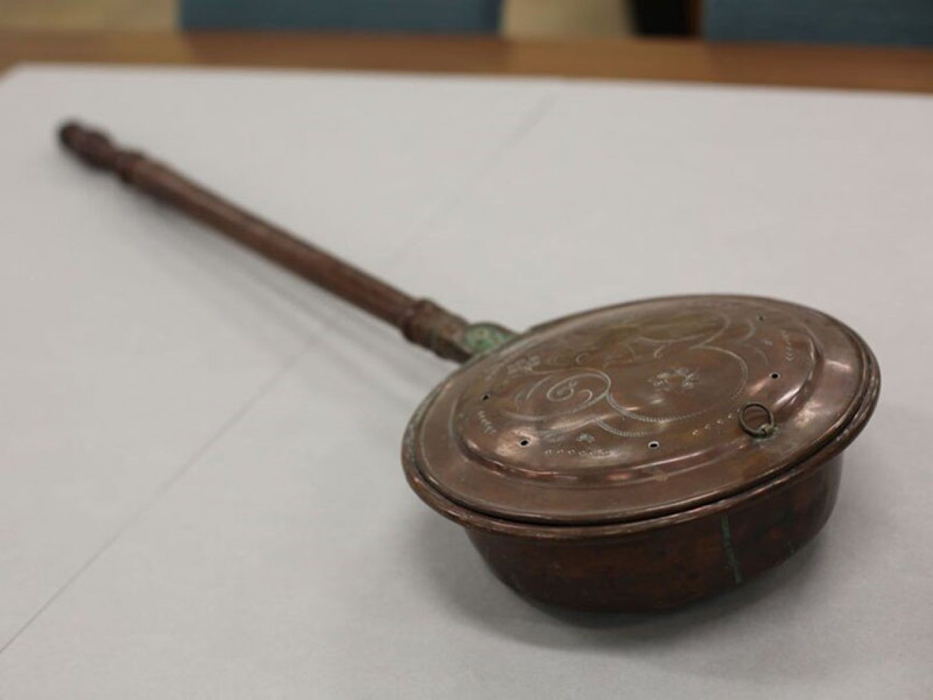
During the month of August the Rosenberg Library is displaying an 1830s surveyor’s compass made of brass. John D. Groesbeck used it in 1838 in one of the early land surveys of Galveston.

| Surveyor’s Compass | Rosenberg Library and Museum |
A History of Surveyors and Their Tools
As long as there have been people inhabiting the earth there has been a need to accurately map and measure land. This practice of measuring land is known as surveying, and the people who survey it are known as surveyors. Surveying is used to create maps, plan construction, and define the boundaries of property ownership. It is an old practice dating back to ancient Egypt and Greece. In fact, the ancient Egyptians used surveying to help build the Great Pyramids of Giza, and prehistoric surveyors used measuring tools to create Stonehenge.
Surveying has its own unique history in America. Many of the founding fathers such as George Washington and Thomas Jefferson were land surveyors. In the colonial era there was an increased demand for surveyors and surveying equipment as settlers continued to develop the land and establish boundaries.

| George Washington Surveying | Rosenberg Library and Museum |
One of the most popular methods for surveying land during this era was using a chain and a compass together. The chain, known as Gunter’s Chain, was developed in 1620 and consisted of 100 links that measured 66 feet in total. A total of ten chains would equal one acre. Surveyor’s compasses, also known as circumferentors, were developed around the 1610s to measure horizontal angles with magnetized needles.
Originally surveyor’s compasses were made of wood. However, around the 1730s, brass became the primary material as it became cheaper to use. Skilled craftsmen made the surfaces of their compasses into detailed works of art. These brass compasses were much more durable than wooden compasses and became the favored tool of surveyors.
Surveyor’s compasses have a pair of vertical sights for sighting along a line. Surveyors would look through the sights to measure the angle between two points. In order to get an accurate reading a surveyor’s compass had to be completely level. Therefore, surveyors mounted their compasses on tripods or a single staff so they could get accurate measurements.
The surveyor’s compass in our collection dates to the 1830s. It is missing its vertical sights but is otherwise intact. It was made by Oscar Hanks in Troy, New York. Oscar Hanks hailed from a famous family of inventors who were renowned for their surveying instruments and continued to pioneer surveyor’s compasses.
The museum also has another compass that was created by Oscar Hanks. This compass was made around the same period, but it is a pocket compass used for navigation rather than surveying. Captain Norman Hurd owned and used it at sea aboard the Texas Navy Ship Brutus.

| Compass | Rosenberg Library and Museum |
Surveying in Galveston
There were multiple land surveys conducted over the years in Galveston. Each survey helped to create a more detailed plan and better map for the city of Galveston. John D. Groesbeck used the surveyor’s compass in our collection for the second survey of Galveston under the direction of the Galveston City Company.
John D. Groesbeck, born on April 13th, 1816, in Albany, New York, was trained as a civil engineer and came to Galveston with his cousin in the 1830s. In addition to being a surveyor, Groesbeck was the first wholesale druggist in Texas, operated a liquor store that sold fine wine and spirits, and worked as a commercial editor for the Galveston Daily News. He also served as an alderman for Galveston in 1840. After marrying in 1846, Groesbeck settled in San Antonio where he continued life as a successful merchant. Groesbeck finished the map from this land survey in 1838 but the map was not printed until 1858.

| Galveston Map | Rosenberg Library and Museum |
Groesbeck platted the city site, meaning he divided the land of Galveston into plots on a map. Platting allows for the creation of clear property boundaries and the planning of important infrastructure such as roads.
Groesbeck also named the streets according to a pattern that was already established by the city of Philadelphia. Avenues that ran east and west were put in alphabetical order, beginning at the bay with Avenue A. The streets that ran north and south were put into numerical order, beginning in the east with First Street. He located cemeteries at the northwest corner of the city and set aside land for five churches, three schools, three markets, a customs house, and a courthouse. Although Galveston has changed in many ways since Groesbeck first presented his layout of the city, several core ideas remain. It’s amazing to see how much Galveston has grown since then!
The Treasure of the Month is located on the library’s historic second floor near the East Entrance. It can be viewed during regular library hours, 9:00 a.m. to 5:45 p.m. Monday through Saturday and from 9:00 a.m. – 8:45 p.m. on Tuesdays and Thursdays. For more information, please contact Ivy Albright, Museum Curator at 409.763.8854 Ext. 125 or at museum@rosenberg-library.org.

Relax, Unwind, and Enjoy Luxury

Experience Life
Rosenberg Library
Rosenberg Library has offered over a century of community service to the Galveston area, and is the oldest public library in Texas in continuous operation. The building itself was dedicated on June 22, 1904, the birthday of its patron, Henry Rosenberg. The Moody Memorial Wing opened in 1971, more than doubling the floor space and allowing for a children’s library, a history center, several galleries to showcase museum collections, and later, a computer lab. The Library accepted its first museum piece shortly after it opened in 1904. Since then, thousands of rare and interesting objects from around the world have been added to the collection. Each month they display a “Treasure of the Month”. Learn more by visiting the Rosenberg Library page and the Gifts of Henry Rosenberg section.